ASEG is pleased to announce its collaboration with SEG for the highly anticipated Sixth International Conference on Engineering Geophysics (ICEG) that will be held from 25 - 28 Oct 2021 Virtual | Cape town South Africa. This provides us the opportunity to provide all ASEG Members to ATTEND virtually with an interactive an immersive experience and the ability to connect with like-minded individuals from across the globe.
ASEG members receive a discounted price of $250 USD by contacting Suba Jaganathan on sjaganathan@seg.org.
ICEG 2021 will concentrate on global innovation, creativity, advances, and new approaches in the field of engineering/environmental geophysics and related fields. In addition to the core engineering/environmental and geotechnical focuses of this coming event, special sessions in related applications of archaeology, energy and forensic geophysics will be included.
To view the entire technical programme, please visit our website where you can download it.
Geophysics in Geothermal Energy – Today and Tomorrow
12–14 October 2021 | Virtual Workshop
ASEG is pleased to announce its collaboration with SEG for the highly anticipated Geophysics in Geothermal Energy – Today and Tomorrow workshop is up on our website. Be a part of this highly-anticipated virtual event that will be taking place from 12–14 October. This provides us the opportunity to provide all ASEG Members to ATTEND virtually with an interactive an immersive experience and the ability to connect with like-minded individuals from across the globe.
ASEG members receive a special discounted price of $US320. In order to benefit from the above rates, they should contact Suba Jaganathan on sjaganathan@seg.org.
Our technical committee has created a special workshop that branches out into specific topics that run parallel to each other, thus attendees can curate and choose the session they would like to view. A recording will also be available within 24 hours for attendees to re-watch any session they have missed, thus providing an enriching and wholesome experience throughout the workshop. We encourage anyone involved in geoscience or geothermal resource exploration to join in on this informative conversation: seismic processers, petrophysicists, rock physicists, geologists, geophysicists, geomechanicists and reservoir engineers.
To view the entire technical programme, please visit our website where you can download it, or watch the video for what you can look forward to during the workshop:
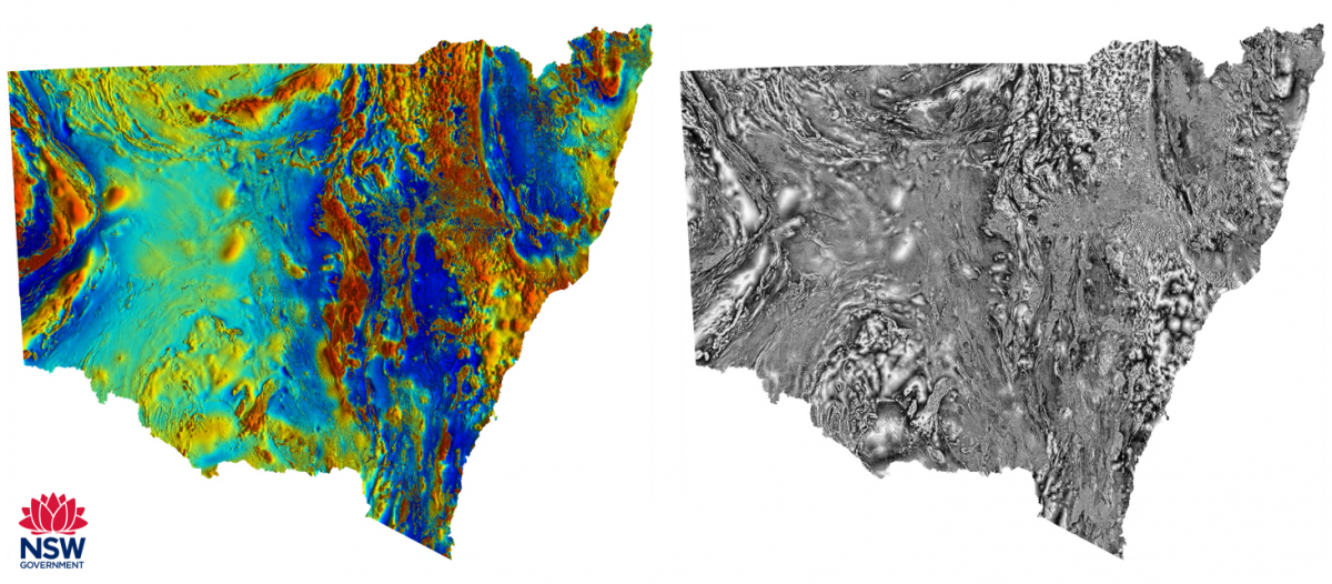
Sam’s talk will provide a behind the scenes look at the creation of enhanced statewide geophysical merges incorporating high resolution company data. Following the QA/QC and metadata harvest from decades of legacy geophysics data, a specially created algorithm is applied to provide a quantitative aid in survey selection for inclusion in the merges. A small data workshop is included which highlights how all open-file geophysical data in NSW can be accessed for free through our online portal MinView.
Astrid’s talk will detail the expansive array of regional geophysics occurring throughout NSW from 2021 and into the future. The recent completion of the Cobar AEM and AMR surveys, as well as the Mundi AEM survey are only the tip of the iceberg in NSW. A wealth of regional geophysical surveys spanning a wide range of techniques are also in the works and promise exciting data.
In 2019 OZ Minerals released more than 2TB of company data challenging teams from around the world to compete for $1M in prize money by predicting mineralisation locations in the Mount Woods area of the Gawler Craton. The area is best known for the Iron-Oxide Copper Gold (IOCG) Prominent Hill deposit. Three former colleagues, Randall Taylor, Karen Aurisch and Bronwyn Davies with many years of combined petroleum exploration experience, but relatively little direct experience of mineral exploration, joined forces to analyse the data and submit an entry. This talk will present their methodology and results and compare it to the brief public disclosure of the winning entry.
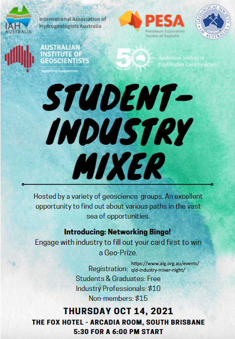
Also on Thursday the 14th of October there is a combined Industry, Society, Early Career and Student Networking function held at the Fox Hotel. The flyer with specific details is below and registration is through the AIG website
Topic: Developing a Facies Architectural Outcrop Analog for Kuwait Formation at Jal Az-Zor Escarpment to understand Stratigraphic Controls on Heavy Oil Production Northern Kuwait
Date & Time: Sep 28, 2021 06:30 PM in Canberra, Melbourne, Sydney
Presenter: Salah El-Ekhfifi,exploration geologist,NOC,Libya and Aimen Amer
The Goal of this work is to develop an outcrop analog that can explain subsurface reservoir architecture.
This will be established through two methods:
1) conventional facies modeling and
2)forward stratigraphic modeling.
By applying these two methodologies, we will reinterpret an enigmatic elongated geobody in the subsurface and explain, how such feature is an excellent stratigraphic trap
After registering, you will receive a confirmation email containing information about joining the meeting.
I hope to see you on Thursday night, and don't forget to wear something from 'where you would rather be,' and bring along your best/funniest/worst fieldwork stories to share with the group (if you want to), and your favourite drink and snacks.
We will have prizes on offer- you have to be in it to win it!
Let's all get together for a chance to have some fun, and to make lockdown a little less bleak for the east-coasters who might be getting cabin fever.
It is also with great delight and excitement that myself, and Honours and Awards Chair Andrew Mutton, invite you to the ASEG Honours and Awards Ceremony that is open to everyone (not just conference attendees). This will be held during the lunch break on the first day of the conference talks (Wednesday 15th September) at 12 pm AEST. I cannot wait to share with you all the extremely deserving recipients of these awards and hope that you will join me online through Zoom to celebrate these outstanding achievements- click here to register.
Abstract: The proliferation of large seismic arrays have opened many new avenues of geophysical research; however most techniques still fundamentally treat regional and global scale seismic networks as a collection of individual time series rather than as a single unified data product. Wavefield reconstruction allows us to turn a collection of individual records into a single structured form that treats the seismic wavefield as a coherent 3D or 4D entity. We propose a split processing scheme based on a wavelet transform in time and Laplacian preconditioned curvelet based compressive sensing in space to create a sparse representation of the continuous seismic wavefield with smooth second order derivatives. Using this representation, we will illustrate three applications that require accurate access to the full wavefield including spatial gradients -
Bio: Jack Muir
Jack is a 6th year graduate student in geophysics at the California Institute of Technology Seismological Laboratory (Caltech Seismolab) –- he will take up a Marie Skłodowska-Curie Fellowship at the Oxford University Department of Earth Sciences in late 2021 / early 2022, and is currently a visiting researcher at the Australian National University. He is passionate about inverse problems — some of the projects he is working on now are: imaging the Earth from near surface to the core; improving data captured at seismic arrays; and answering difficult questions about historical data sets.